8.微信小程序之地图demo
大佬让我调研一下微信小程序的地图怎么使用,写个一demo。
怎么感觉有好多坑。。。
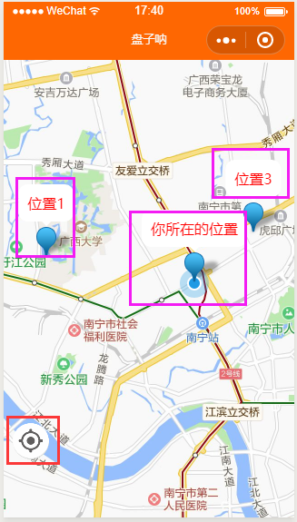
一.效果图
1.用markers显示标记点,用callout自定义气泡弹窗,如图粉红框所示。点击标记点,可以打印信息;
2.随便拖动地图到任意位置,点击红色框中的内容可以返回初始位置,即“你所在的位置”
3.拖动结束时,获取地图中间的经纬度,控制台可看见信息
二.代码
1.map.wxml
<map id="map"longitude="{{longitude}}"latitude="{{latitude}}"show-locationscale='15'markers="{{markers}}"bindmarkertap="markertap"controls="{{controls}}"bindcontroltap="controltap"bindregionchange="regionchange"></map>
2.map.wxss
#map{width: 100%;height: 100vh;}
3.map.js
说一个注意点。markers是标记点用于在地图上显示标记的位置,用callout可以在标记点上显示气泡弹窗,气泡弹窗中的属性fontSize、borderRadius、padding不能是字符串,必须是数字,否则没效果。
目前,markers的数据是写死的,待完善。
// pages/map/map.jsvar app = getApp();Page({/*** 页面的初始数据*/data: {latitude: 0,longitude: 0,controls: [{id: 0,iconPath: "../../image/position.png",position: {left: 10,top: 400,width: 40,height: 40},clickable: true}],markers: [{longitude: 108.31343,latitude: 22.83393,id: 0,width: 35,height: 30,callout: {content: "你所在的位置",color: "#ff0000",fontSize: 16,borderRadius: 10,bgColor: "#ffffff",padding: 10,display: "ALWAYS"}},{longitude: 108.28544,latitude: 22.83844,id: 0,width: 35,height: 30,callout: {content: "位置1",color: "#ff0000",fontSize: 16,borderRadius: 10,bgColor: "#ffffff",padding: 10,display: "ALWAYS"}},{longitude: 108.26073,latitude: 22.84558,id: 0,width: 35,height: 30,callout: {content: "位置2",color: "#ff0000",fontSize: 16,borderRadius: 10,bgColor: "#ffffff",padding: 10,display: "ALWAYS"}},{longitude: 108.324590,latitude: 22.842579,id: 0,width: 35,height: 30,callout: {content: "位置3",color: "#ff0000",fontSize: 16,borderRadius: 10,bgColor: "#ffffff",padding: 10,display: "ALWAYS"}},]},/*** 生命周期函数--监听页面加载*/onLoad: function (options) {var that = this;//获取当前位置wx.getLocation({success: function (res) {console.log(res);that.setData({longitude: res.longitude,latitude: res.latitude,})}})},/*** 生命周期函数--监听页面显示*/onShow: function () {this.mapCtx = wx.createMapContext('map'); //获取地图存入变量},markertap(e) { //点击标记console.log(e);},regionchange(e) { //拖动地图if (e.type == 'end') { //如果拖动结束,也就是松开手指console.log('拖动结束,下面获取地图中间的经纬度');this.mapCtx.getCenterLocation({ //获取屏幕中间的经纬度success: function (res) {console.log(res)}})}},controltap(e) { //点击左下角的固定按钮console.log(e.controlId)if (e.controlId == 0) { //如果ID是0,返回当前位置this.mapCtx.moveToLocation()} else if (e.controlId == 1) {}},})


![洛谷 P1169 [ZJOI2007]棋盘制作](https://image.dandelioncloud.cn/images/20230808/72ba490c52904facb1bad28940d1f12a.png "洛谷 P1169 [ZJOI2007]棋盘制作")


还没有评论,来说两句吧...